


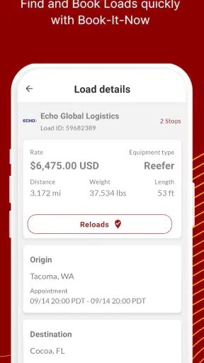
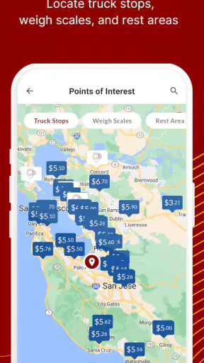
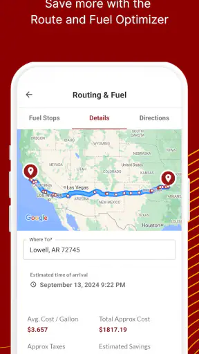
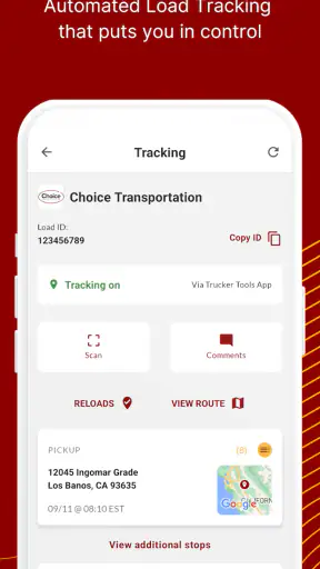
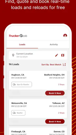
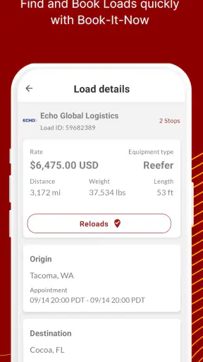
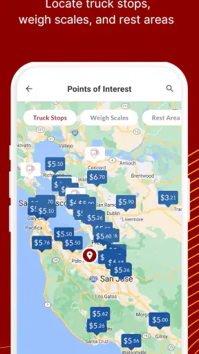
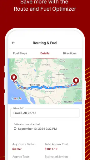
Long-haul driving is full of decisions that depend on current information: where to stop, how to plan the next leg, and whether a promising parking option is still useful when you arrive. I spent time looking at Trucker Tools as a mobile navigation companion for those moments, rather than treating it like a general-purpose map replacement. Its focus is clearly professional trucking, and that focus makes a difference in both its usefulness and its limits.
Developed by Trucker Tools, this free Maps & Navigation app has built a sizeable audience, with more than a million installs and an average rating of 3.9 from roughly 9,000 ratings. Those numbers suggest a tool many drivers find worthwhile, but not one that works perfectly for everyone. My overall impression is that it is most valuable when I use it as part of a connected trip-planning routine, with enough patience to verify important details before committing to a route or stop.
How connectivity shapes the driving experience
Useful when the road plan is changing
The strongest reason to try this app is that trucking decisions are rarely static. A driver may begin a shift with one destination in mind and then need to reconsider the timing, stopping point, or practical route. A navigation tool designed around truckers is more relevant in that situation than a standard map app built mainly for private cars.
The app’s store summary describes a new and improved experience trusted by more than 350,000 drivers. I would read that as a sign of its intended audience: people who spend serious time on the road and need a specialized companion, not casual travelers looking for directions to a restaurant. The app is free, which makes it easy to test without first committing money to a subscription or purchase.
Connectivity matters because the value of a current trucking tool depends on information being refreshed while the driver is planning. When the phone has a reliable connection, I can approach the app as a live planning aid: check what appears relevant before departure, reassess during a break, and avoid assuming that an earlier plan still matches the situation later in the day.
That does not mean I would rely on any navigation app blindly. For a commercial driver, a route that looks convenient on a screen still needs to be judged against the vehicle, delivery requirements, road restrictions, weather, and personal knowledge of the area. The app can support those decisions, but it should not replace them.
Why the mobile setting changes the workflow
Using a trucking app on a phone is different from researching a trip at a desk. The screen is smaller, attention is limited, and the driver may be checking information during a short break rather than sitting down for a long planning session. I found that the best approach is to do the detailed thinking before moving and keep in-motion interaction as simple as possible.
For example, imagine finishing a delivery later than expected and needing a practical place to stop. I would not wait until the last few minutes of driving to open the app and make several decisions at once. I would pull over, check the available information, compare it with the remaining driving time, and then decide whether the proposed stop actually fits the vehicle and schedule. That small change in habit makes the app more useful and safer to handle.
A second mobile issue is the phone itself. Bright sunlight, a dashboard mount, battery drain, and an unreliable signal can all affect how comfortable the experience feels. Even a well-designed trucking tool becomes frustrating if the screen is difficult to read or the device is nearly out of power. I would keep a charging arrangement ready and avoid treating the phone as the only source of trip information.
The app supports Android devices running version 7.0 or later, so it is accessible to people using older compatible phones as well as newer models. That broad compatibility is helpful for drivers who keep a dedicated work phone instead of upgrading frequently. At the same time, an older device may feel slower when several apps are open, so the practical experience will depend partly on the phone being used.
What happens when the connection is weak
The most important caution is simple: I would plan around the possibility that connectivity may become unreliable. I would not assume that every part of the experience remains available in a dead zone, and I would not begin an unfamiliar route without first understanding the plan well enough to continue safely if the app stops updating.
This is especially important in rural stretches, industrial areas, mountain roads, and large truck stops where a signal may behave unpredictably. A connection can appear adequate during planning and then become inconsistent after leaving town. If I were using the app to identify a stopping option, I would review the relevant details while connected and keep the destination or next step clear before pulling away.
That habit also reduces distraction. Instead of repeatedly checking for changes while driving, I can make a decision during a legal, safe pause and then concentrate on the road. The app is more useful when connectivity supports a deliberate workflow, not when the driver is constantly trying to force a live answer from a weak signal.
There is another kind of failure to consider: information can be current and still not match reality perfectly. A busy facility may fill up after the information was viewed, access may be awkward for a particular rig, or local conditions may change. I treat any digital result as a lead to verify, not as a guarantee. That is a limitation shared by many connected navigation services, but it matters more when a missed stop can affect the entire shift.
A practical recovery routine
When something does not load or the connection drops, my preferred recovery method is to stop making the problem bigger. I would avoid repeatedly tapping through screens while moving, pull over when necessary, and return to the last useful piece of information I had already reviewed. If the app becomes unavailable, a driver should fall back to safe, familiar planning methods rather than improvising from a half-loaded screen.
Before setting off, I would also note the next major decision point in plain language: the intended destination, the approximate area for a break, or the point at which I need to reassess. This is not a claim that the app provides a special offline mode; it is simply a sensible way to reduce dependence on a continuous connection. The phone can assist the plan, but the plan should not disappear the moment the signal does.
Recovery is easier if the app is used in stages. First, I would use it during a stationary planning session. Next, I would confirm the choice against the truck’s needs and the day’s schedule. Finally, I would start driving only after I know what I am trying to accomplish. That sequence is more reliable than opening the app for the first time when fatigue and time pressure are already high.
Managing data and battery during a long shift
Connected navigation can consume more than attention. It may also use mobile data and battery, especially when a driver keeps a screen active for long periods or switches repeatedly between navigation and other tools. I would not assume that a free app means the entire phone experience has no cost; the app itself is free, while the driver’s mobile plan and power supply remain practical considerations.
A data-conscious routine starts with preparation. I would use a stable connection before leaving to review the trip, avoid unnecessary refreshing, and close unrelated apps that compete for battery or make the phone harder to manage. During a break, I would check only what has changed instead of leaving the app open continuously without a clear reason.
This approach is particularly useful for drivers with limited data plans or older phones. It also makes the app less distracting. A tool that is checked with a purpose is easier to fit into a professional routine than one that becomes a constant stream of updates. If the phone is shared between navigation, calls, electronic logging, and dispatch communication, conserving battery is not a minor detail.
I would also keep the display setup realistic. A mounted phone can be useful, but the driver should not be reaching across the cab or trying to read small text while moving. The safest use is to make adjustments while parked and rely on the chosen plan during the driving portion. Connectivity should make planning easier, not encourage more screen interaction.
Where it fits beside ordinary map apps
Compared with a general map application, this app has a clearer professional identity. A standard map is often excellent for finding businesses, checking streets, or getting familiar with an area, but it may not reflect the way a truck driver thinks about a trip. The relevant question is not simply “How do I get there?” It is also “Can this plan work for my vehicle, my hours, and my next stop?”
I would therefore use ordinary maps as a secondary reference rather than an automatic substitute. They can help confirm a street layout or identify a nearby landmark, while Trucker Tools is the more natural place to begin when the trip is shaped by trucking needs. Neither option removes the need for judgment, and neither should be treated as a promise that every route or stop will suit every rig.
On the other hand, a driver who only needs occasional directions may find a specialized trucking app unnecessary. If the work involves short local trips, familiar roads, or a vehicle with few route restrictions, a general navigation app may feel faster and simpler. The specialized focus becomes more valuable as the trip becomes longer, less familiar, and more dependent on practical stopping decisions.
Who will get the most from it
I see the best fit in over-the-road drivers, regional operators, and anyone who regularly has to think ahead about the next workable stage of a journey. It can also help newer drivers develop a more structured planning habit: review the route while stationary, identify the next decision, and leave enough time to change course if the first idea is not suitable.
Experienced drivers may appreciate it differently. They already know many roads and stopping areas, so the app is less about replacing knowledge and more about adding another connected reference when conditions or schedules change. In that role, it can save mental effort without asking the driver to surrender control of the trip.
I would skip it if I wanted a simple, universal navigation experience with no trucking-specific learning curve. I would also hesitate to make it my only tool if my routes frequently pass through areas with poor service or if my work depends on highly precise operational information that must be confirmed through another channel. The app is a useful companion, not a complete professional driving system.
Version, accessibility, and everyday practicality
The current version is 10.3.3, and the app has been available since August 1, 2011. That long presence gives it a mature place in the trucking-app landscape, while the current release shows that it continues to be maintained as a modern mobile product. I would still update it before an important trip rather than waiting until departure day, because last-minute changes can create unnecessary friction.
Its Everyone content rating makes it broadly accessible from an age-rating perspective. That does not change the need for responsible use: anything involving route decisions should be handled by the driver only when safely stopped or through an appropriate hands-free setup. The rating describes audience suitability, not permission to interact with a phone while driving.
The audience size is another useful signal. With around 9,000 ratings and about 3,000 written reviews, the 3.9 average feels more informative than a perfect score would. It tells me that the app is established and useful to many people, but that individual expectations and real-world connectivity still matter. I would install it before a demanding trip, test my workflow on a familiar route, and decide whether it fits my phone and habits.
My connectivity verdict
My recommendation is positive, with one condition: use Trucker Tools as a connected planning assistant, not as an unquestioned source of truth. Its trucking focus makes it more relevant than a normal map app for drivers who regularly manage long routes and changing stop decisions. The free price and broad Android compatibility also make trying it relatively easy.
The main trade-off is dependence on a sensible mobile routine. Weak service, battery limits, changing road conditions, and information that needs real-world verification can all interrupt the ideal experience. I would prepare while connected, make decisions while parked, keep a fallback plan, and avoid assuming that a live app can solve every problem once the signal disappears.
For a professional driver who wants another practical tool in the cab, that trade-off is reasonable. For someone seeking effortless turn-by-turn directions for occasional personal travel, a general map app may be the better choice. After weighing both sides, I think this app earns a place in a trucker’s toolkit when it is used thoughtfully: connected when possible, checked before departure, and always supported by the driver’s own judgment.


